Cao Bang, Bac Kan – Investment Potential and Opportunities
Bac Kan is a mountainous province located in the central region of Northeast Vietnam. It borders Cao Bang Province to the north, Thai Nguyen to the south, Lang Son to the east, and Tuyen Quang to the west. The provincial town is located about 170 km north of Hanoi.
The climate and soil conditions here are favorable for the growth of both natural vegetation and planted forests. Bac Kan is home to over 1,000 plant species, including more than 300 species of timber trees, hundreds of medicinal plants, and over 50 species listed in the Red Book. On average mountain peaks and limestone ranges, many slow-growing hardwood trees can be found — some are hundreds of years old, such as trai, dinh, nghien, lac, cho, and red pine. The province also boasts homogeneous forests of bamboo species such as vau, nua, truc, and may thoc. Forestry remains Bac Kan’s primary economic strength.
Bac Kan is also home to primeval forests, including the Kim Hy Nature Reserve and Ba Be National Park, which shelter over 400 plant species and nearly 30 animal species.
National Highway 3, which runs 123.5 km through the province, is a vital transportation route for economic and social exchange with neighboring provinces. In addition, National Highway 279 connects Bac Kan with Lang Son, Tuyen Quang, and Ha Giang provinces, while National Highway 3B links Bac Kan Town to Trang Dinh District in Lang Son.
The province’s terrain is primarily mountainous, making up three-quarters of the natural land area. It is sharply divided with a mix of rocky and earthy mountains, with an average slope of 26–30 degrees. This topography creates valleys and small, narrow fields scattered throughout. The complex and diverse terrain results in a variety of ecological sub-regions suitable for different types of crops and livestock.
There is significant land potential for forestry development and animal husbandry. Currently, agricultural, forestry, and livestock production are mainly small-scale, scattered, and self-sufficient — typical of the local population.
Besides the potential for large-scale farms and plantations, the valleys offer excellent conditions for aquaculture, particularly for new high-value species such as salmon and sturgeon.
The Ta Lung border gate in Cao Bang, about 180 km from Bac Kan Town, facilitates the export of agricultural products, livestock, and poultry across the border.
With a fairly well-developed transportation system between Hanoi and Bac Kan, the region holds promising investment potential in tourism and farm-based tourism in the near future.
Following a field survey in July 2009, we would like to share with readers and potential investors some images of agriculture in Bac Kan and Cao Bang:


- Terraced rice fields (Bac Kan). Photo: Viet Linh
- Click here to view rice planting techniques
- A stream running through the valley (Bac Kan). Photo: Viet Linh
- Diverse vegetation cover (Bac Kan). Photo: Viet Linh
- Plantation forest (Bac Kan). Photo: Hoang Lam Son / Viet Linh
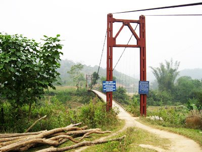
- Bridge to a village (Bac Kan). Photo: Hoang Lam Son / Viet Linh
- Road into a commune (Bac Kan). Photo: Hoang Lam Son / Viet Linh
- Crossing a stream (Bac Kan). Photo: Hoang Lam Son / Viet Linh
- Mountainous terrain with lush greenery. Photo: Viet Linh
© Viet Linh. August 1, 2009